Handy Surveying


Handy Surveying - Land Surveying Tool
App stats
Ranking
Other platforms
App summary
This fully featured surveying app has been developed in consultation with experienced surveyors in both Australia and the US and includes many of the common Coordinate Geometry (COGO) calculations needed for land surveying field work.
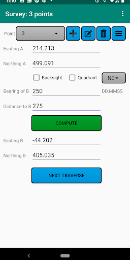
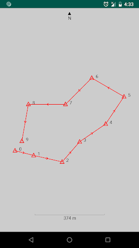
The app can store points for multiple jobs simultaneously, and can easily compute and store the next point on each leg of a continuous bearing and distance traverse. Once a traverse has been completed, it can be plotted, exported, and the misclosure can be computed and corrected if desired.
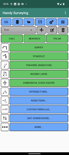
Functions include:
* Conduct a survey as a continuous bearing and distance traverse, automatically storing points in a point database, optionally using a backsight or quadrants.
* Stakeout points on the ground from a plan
* Plot survey points
* List and edit survey point coordinates
* Import and export survey points from/to a CSV file
* Compute the misclosure distance and angle
* Automatically correct the misclosure using the Bowditch method.
* Compute enclosed area and perimeter
* Traverse / Radiation (2D and 3D)
* Inverse / Join (2D and 3D)
* Horizontal curve solver
* Intersection by bearings
* Intersection by distances
* Intersection by bearing and distance
* Intersection of two lines
* Intersection of perpendicular lines
* Two point and three point resections
* General purpose calculator with trig functions and degree conversion tool
* Bearing calculator
* Polar to rectangular tool
* Calculate the line of best fit for a set of points
* Units conversion tool
* Point Scale Factor
* Grid Convergence
* The ability to add your own custom formulas to the app
The app defaults to bearing entry and display in DD.MMSS format, but you can also select D/M/S, Decimal Degrees (Dec Deg), or Gradians (Grad) formats. You can also choose for northings to appear before eastings, or for bearings to be relative to north or south using options on the preferences page.
A version of this app is also available for iOS.
User reviews
Similar apps
Here are some Android apps that are similar to Handy Surveying: